Agriculture
Transforming Agriculture with Precision Drone Solutions for Smarter Farming and Higher Yields.
Transforming Agriculture with Precision Drone Technology
Why Agriculture Needs the Precision of Drones

Choose Vyomik for unmatched expertise in agricultural drone solutions that enhance productivity and sustainability. Our innovative technology empowers farmers with real-time data insights, precision spraying, and efficient resource management, driving smarter farming practices and better yields.
Precision and Efficiency
Cost-Effective Farming
Eco-Friendly Solutions
Real-Time Insights
How Vyomik Helps Agriculture
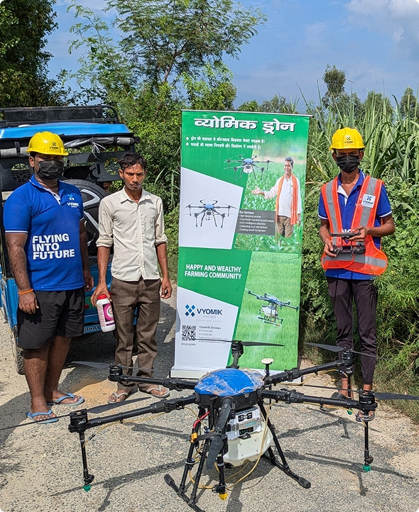
Vyomik helps agriculture by offering innovative drone solutions that optimize crop management, monitor field health in real-time, and enhance productivity through precise, data-driven farming practices.
Drones for Agriculture Spraying

Deliverables
Pesticide Spraying
Fertilizer Spraying
Crop based Intelligent Spraying
Agriculture Field Mapping

Deliverables
Orthomosaic Maps
Digital Surface Model (DSM)
Digital Terrain Model (DTM)
Digital Elevation Model (DEM)
Contour Mapping and Elevation Profile
3D Point Cloud Models
Crop Health Analysis

Deliverables
Plant Stress Analysis
Pest Analysis
Plant Disease Analysis
Weed Analysis
Plant Stand Count
Growth and Fertility Monitoring

Deliverables
Stand Counts
Plant Stress Analysis
Plant Disease Analysis
Periodic Surveys for Growth Comparison
How Vyomik Helps Agriculture
Drones for Agriculture Spraying
Deliverables
Pesticide Spraying
Fertilizer Spraying
Crop based Intelligent Spraying

Agriculture Field Mapping
Deliverables
Orthomosaic Maps
Digital Surface Model (DSM)
Digital Terrain Model (DTM)

Digital Elevation Model (DEM)
Contour Mapping and Elevation Profile
3D Point Cloud Models
Crop Health Analysis
Deliverables
Plant Stress Analysis
Pest Analysis
Plant Disease Analysis

Weed Analysis
Plant Stand Count
Growth and Fertility Monitoring
Deliverables
Stand Counts
Plant Stress Analysis
Plant Disease Analysis

Periodic Surveys for Growth Comparison
How Vyomik Helps Agriculture
Drones for Agriculture Spraying
Deliverables
Pesticide Spraying
Fertilizer Spraying
Crop based Intelligent Spraying

Agriculture Field Mapping
Deliverables
Orthomosaic Maps
Digital Surface Model (DSM)
Digital Terrain Model (DTM)
3D Point Cloud Models
Contour Mapping and Elevation Profile
Digital Elevation Model (DEM)

Crop Health Analysis
Deliverables
Plant Stress Analysis
Plant Disease Analysis
Plant Stand Count
Weed Analysis

Growth and Fertility Monitoring
Deliverables
Plant Disease Analysis
Plant Stress Analysis
Periodic Surveys for Growth Comparison
Stand Counts

Transforming Agriculture with Drone Technology
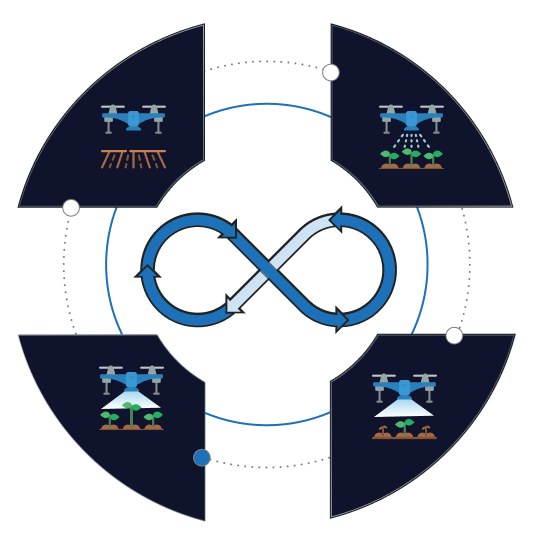
Enhancing precision, efficiency, and sustainability through advanced mapping, spraying, and crop monitoring.
Agriculture Field mapping
Growth and Fertility Monitoring

Drones for Agriculture spraying
Crop Health Analysis

Agriculture Field mapping
Growth and Fertility Monitoring
Drones for Agriculture spraying
Crop Health Analysis
- Real-time Data Collection
Instant high-resolution data capture for monitoring crops, infrastructure, and security.
- Precision Mapping
Detailed maps and 3D models for farming, terrain analysis, and infrastructure assessment.
- Automated Operations
Automation boosts efficiency in crop spraying, utility inspections, and mining surveys.
Why struggle with labor-intensive farming practices?
Let us help you with our drone technology, designed to simplify and enhance your farming operations.
Testimonials from Our Satisfied Clients
Explore their testimonials to see how Vyomik drones are making a significant difference across diverse sectors
Vyomik drones enhance our mining efficiency with precise aerial mapping, ensuring safer navigation in tough terrain.

Yadagiri
Farmer, Patel Polam

Esther Howard
Mining Operations Manager

Esther Howard
Mining Operations Manager

Esther Howard
Mining Operations Manager
Na peru Yadagiri. Nenu ekkada maa Patel polam lo paniki appudappudu ostam. Ee spray cheyyadam, mandu chaladam chestham. Eppudu ee drones tho, padi nimishallo ayyepothudi! Adhey menu ayythey, aa bag vesukoni burdha lo velli chestham, maku oka ganta paduthudi. Kani eppudu chal thavaraga ayyedhi. Dhanyavadalu ee drone vaalaki!
Yadagiri
Farmer
We use Vyomik drones for site surveys. Saves us weeks of manual work. The reports are detailed and help our engineers plan better. Definitely a game-changer for us.
Amit Sharma
Civil Engineer
Deepak Nair
Operations Head
Ravi Verma
Municipal Officer
Manoj Patil
Mining Surveyor
Vyomik drones enhance our mining efficiency with precise aerial mapping, ensuring safer navigation in tough terrain.

Esther Howard
Mining Operations Manager
Na peru Yadagiri. Nenu ekkada maa Patel polam lo paniki appudappudu ostam. Ee spray cheyyadam, mandu chaladam chestham. Eppudu ee drones tho, padi nimishallo ayyepothudi! Adhey menu ayythey, aa bag vesukoni burdha lo velli chestham, maku oka ganta paduthudi. Kani eppudu chal thavaraga ayyedhi. Dhanyavadalu ee drone vaalaki!
Yadagiri
Farmer
Vyomik drones enhance our mining efficiency with precise aerial mapping, ensuring safer navigation in tough terrain.

Esther Howard
Mining Operations Manager
Amit Sharma
Civil Engineer
Vyomik drones enhance our mining efficiency with precise aerial mapping, ensuring safer navigation in tough terrain.

Esther Howard
Mining Operations Manager
Deepak Nair
Operations Head
Vyomik drones enhance our mining efficiency with precise aerial mapping, ensuring safer navigation in tough terrain.

Esther Howard
Mining Operations Manager
Ravi Verma
Municipal Officer
Vyomik drones enhance our mining efficiency with precise aerial mapping, ensuring safer navigation in tough terrain.

Esther Howard
Mining Operations Manager
Manoj Patil
Mining Surveyor
Unlock the Power of Drone Technologies
Talk to Us About Your Industry Needs
Have questions about our drone solutions or want to discuss how we can optimize operations across agriculture, infrastructure, energy, and more?
- Vindhya C4-202, IIIT-H Campus, Survey no.25, Gachibowli, Hyderabad- 500032
-
+91 9121265555
+91 8940495888 - sales@vyomikdrones.com


